Walking
Cappadocia on foot, among the valleys the wind carved
Cappadocia's landscape was shaped by volcanoes and then unshaped, slowly, by wind and rain. What people did with the soft rock left behind is the more surprising part of the story.
By Arthur Penhallow26 September 20264 min read
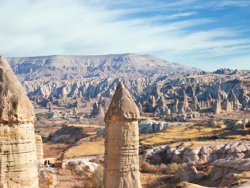
Cappadocia's most famous features look designed, which is precisely backwards. The cone-shaped rock formations known as fairy chimneys, scattered across the region's valleys in their thousands, are the result of two volcanic eruptions millions of years ago that buried the area in soft ash, which then hardened into tuff and was gradually carved by wind and rain into pillars, capped in places by harder, more erosion-resistant boulders balanced improbably on top. Nobody built these shapes. People simply noticed, a very long time ago, that the rock beneath them was soft enough to dig into.
A landscape hollowed out from the inside
Once people started digging, they did not stop modestly. Homes, churches, stables and storage rooms were cut directly into the tuff across Cappadocia, and entire underground cities, most famously at Derinkuyu and Kaymakli, were excavated to a depth of several storeys, complete with ventilation shafts, wells and rolling stone doors that could seal a level off from the inside. These cities are thought to have been used, particularly by early Christian communities, as shelter during periods of raiding and unrest, capable of sheltering thousands of people and their livestock for extended periods entirely out of sight.
Göreme's painted churches
The Göreme valley holds the best-known concentration of rock-cut churches, many of them decorated with Byzantine frescoes dating from the tenth to twelfth centuries, painted directly onto the carved rock and remarkably well preserved by the same dry climate that has kept the fairy chimneys standing. Walking between them, rather than driving the short distance from one to the next, is the only way to appreciate how densely the valley was settled: monastic communities occupied huge stretches of it, chapel after chapel cut into cliffs that from a distance look entirely uninhabited.
Nearby, Uchisar sits on the highest point in the region, a natural rock citadel honeycombed with rooms and passages that served as a fortress and lookout for centuries, with views across the valleys that make clear why the position was worth holding.
A gorge with a river still working on it
South of Göreme, the Ihlara Valley is a different kind of Cappadocian landscape again: a steep, roughly fourteen-kilometre canyon cut by a stream into volcanic rock, its walls riddled with more rock-cut churches, this time reached by paths that drop well below the level of the surrounding plateau rather than rising above it. Unlike the fairy chimneys, still slowly being shaped by wind on the exposed valley floors elsewhere in the region, Ihlara's canyon is the work of running water, cutting down rather than wearing away sideways, and it stays noticeably cooler and greener than the open country above it. Red Valley and Rose Valley, closer to Göreme, take their names from the colour the rock turns in the low light of early morning and evening, when walking paths through them are at their most rewarding and least crowded.
Villages, valleys and a river of pottery
Further afield, Avanos sits on the Kızılırmak, Turkey's longest river, and has been a centre for pottery for centuries, using red clay carried down by the water itself. Mustafapasa, a village of grand stone houses built by a Greek Orthodox community before the population exchanges of the early twentieth century, and Cavusin, with its own abandoned rock-cut church clinging to a cliff face, add a quieter, more domestic layer to a region otherwise dominated by geology and myth. Walking routes through Pigeon Valley, named for the dovecotes carved into its cliffs by farmers collecting droppings for fertiliser, thread between all of these without needing a road.
Why walking suits this landscape
Cappadocia is often seen from above, in a hot air balloon at dawn, and the view has made the region famous well beyond Turkey. Walking it does something different: it puts the fairy chimneys, the painted churches and the underground cities at the scale people actually built and carved them at, rather than the scale they photograph at. A landscape this improbable rewards being taken slowly, on foot, with time to notice which of the shapes are geology and which are several thousand years of very determined excavation.
By Arthur Penhallow, the name Atlas & Passage’s editorial team writes under. Prices and dates in the trips below come from the operators and can change.