Journeys
Iguazú, the falls on the border of Argentina and Brazil
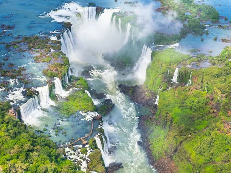
Where the Iguazú river drops off the edge of a plateau in the subtropical forest, it breaks into hundreds of separate waterfalls spread along a great curving cliff. Argentina has most of the falls, Brazil has the view, and seeing them properly means visiting both sides.
By Walter Pellow20 October 20264 min read
The Iguazú river rises near the Atlantic coast of Brazil and flows west across the plateau of southern Brazil for more than a thousand kilometres. Shortly before it joins the great Paraná river, where Argentina, Brazil and Paraguay meet, it reaches the edge of the plateau and falls into a gorge. The result is one of the largest waterfall systems in the world.
The falls stretch for nearly three kilometres along a horseshoe-shaped cliff, and they are divided by islands and rocky outcrops into around two hundred and seventy-five separate falls, depending on the level of the river. Their name comes from the Guaraní words for great water.
The Devil's Throat
The heart of the falls is the Garganta del Diablo, the Devil's Throat, a narrow, U-shaped chasm into which about half the river's water pours from three sides. It is a place of overwhelming noise and spray, where the water vanishes into a cloud of mist and nobody can see the bottom. The border between Argentina and Brazil runs down the middle of the river, through the Devil's Throat.
Two sides, two parks
The falls lie within two national parks, one in each country, and both are World Heritage Sites. Each side gives a different experience.
On the Argentine side, which holds most of the falls, a network of metal walkways leads along the top and bottom of the cliff, through the forest and over the water, bringing visitors right up to the edge of individual falls. A small train runs through the forest to the start of a long walkway across the wide upper river to the lip of the Devil's Throat, where you stand above the plunging water. The lower circuit gives views up at the falls, often with rainbows in the spray. A full day is needed to see it properly.
On the Brazilian side, a single path runs along the far side of the gorge, giving a wide view across to the falls on the Argentine side. That is the panorama, the view that shows the whole scale of the falls. The path ends at a walkway out into the lower river, close to the bottom of the Devil's Throat, where the spray soaks everyone. Half a day is usually enough. Boat trips, on both sides, take visitors into the spray at the foot of the falls.
The towns on each side, Puerto Iguazú in Argentina and Foz do Iguaçu in Brazil, are the bases for visits. Crossing the border between them is straightforward, and many visitors stay on one side and make a day trip to the other. Just outside Puerto Iguazú, at the Three Frontiers landmark, the Iguazú river meets the Paraná, and from one bank it is possible to look across the rivers at both Brazil and Paraguay.
The forest
The falls are surrounded by subtropical rainforest, a remnant of the Atlantic Forest that once covered much of south-eastern South America. It is home to a great variety of wildlife. Coatis, relatives of the raccoon with long ringed tails, roam the paths in groups and have learned to raid visitors' bags. Toucans and parrots fly overhead, great dusky swifts nest behind the curtains of water, and the air is full of butterflies in every colour. Jaguars and other wild cats live in the forest, but they are rarely seen.
Close to the falls, the Itaipú dam on the Paraná river, shared between Brazil and Paraguay, is one of the largest hydroelectric plants in the world, and it can be visited.
Travelsphere's Chile, Argentina and Brazil, thirteen nights, includes Iguaçu Falls with Santiago, Valparaíso, Mendoza, Buenos Aires and Rio de Janeiro.
Explore Worldwide's Buenos Aires to Rio, twelve nights, includes Buenos Aires, Puerto Iguazú, Paraty, Ilha Grande and Rio de Janeiro. Its Pure Brazil, thirteen nights, includes Iguazu with Salvador, Manaus and the Amazon, the Pantanal and Rio de Janeiro.
The falls can be visited all year. The volume of water varies with the rains in the catchment, and is usually highest from about December to March, when it is also hot and humid. The cooler months, roughly from April to September, are more comfortable for walking. Take a waterproof, and a dry bag for your camera.
By Walter Pellow, the name Atlas & Passage’s editorial team writes under. Prices and dates in the trips below come from the operators and can change.